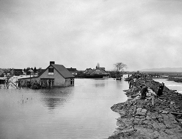
This week was the 69th anniversary of the worst natural disaster to befall Britain in the 20th century, one of the worst ever in fact. On the night of the 31st of January 1953 a storm that began as a depression in the north Atlantic, moved to the North Sea and rolled down the east coast of Britain. Earlier in the day, the storm had already claimed 135 lives when it caused fatal damage to the MV Princess Victoria, an early roll-on/roll-off style ferry operating between Stranraer and Larne in the Irish Sea. This alone was Britain’s worst peacetime maritime disaster.

Tragically, even though the Princess Victoria sank on the afternoon of 31 January, poor communications meant that news of the storm did not reach communities on the east coast. If you look at a map of Britain and the north west coast of Europe you will notice the dramatic narrowing of the North Sea as it reaches Kent and northern France at the English channel. The bit between East Anglia and the Netherlands is shaped like a funnel. And that is exactly how it behaved on the night of 31 January. By tragic coincidence, the storm occurred on the night of a new moon spring tide, when the waters reach high levels anyway. It was, to use an extremely apt expression, ‘a perfect storm’. A huge surge of water could not escape through the channel fast enough and the funnel overflowed in dramatic fashion. The water had nowhere else to go except on to the low-lying flatlands of Norfolk, Suffolk, Essex, Lincolnshire, and most devastatingly of all, the Netherlands.

Because it occurred in the middle of the night, many homes flooded while their inhabitants slept. Many of those coastal homes were poorly built, timber framed and single-storey. In all, 326 people died in Britain. A further 230 deaths at sea can be attributed the storm. In the Netherlands, there were 1,863 deaths, much of the land being below sea level. The Netherlands has been no stranger to devastating flooding over the centuries and so it has long taken its sea defences programme very seriously, but even the renowned Dutch ingenuity at dealing with the sea was no match for a surge which saw sea levels on that night rise to 5.6m above the norm.

I know Zeeland, the southernmost region of the Netherlands and the worst affected by the floods, well; I have been visiting it regularly for twenty years. And I first learned about the 1953 storm surge when I was there in 2003 and there were commemorations to mark the 50th anniversary. There is a museum which tells the story of that night in fascinating and very poignant detail. The last time I was there they had a virtual reality exhibit where you could see what it was like to be surrounded by rising waters inside your own home. It seemed to me extraordinary that I had never heard about the disaster at home, even though I grew up in Essex.
I have been wanting to write about this neglected piece of British history for a very long time and have been ruminating on a novel which I had hoped might be publishable on the 70th anniversary of the disaster (this time next year) – if I’ve any hope of meeting that deadline I’d better get my skates on! In December I made a long-delayed trip to Canvey Island in Essex to undertake some research. Sadly, the Canvey Island Heritage Museum, the only museum I know of in the UK which has information about the floods, has been closed since the start of the pandemic. But just walking around the island (it is tiny) gave me a powerful sense of what it might have been like. Canvey Island lies in the Thames estuary and is separated from its nearest town, Benfleet, by a wide creek. Until the early 1900s, the only means of access was via a causeway at low tide, on foot or by horse and cart. Canvey lies barely above sea level and 58 people on the island lost their lives on the night of 31 January, many of them children. It suffered the greatest loss of any of the towns and villages affected that night.
The memories of the island’s terrible experience are still palpable today. Along the sea wall, a powerful mural depicts some of the stories of that terrible night. I remember visiting Canvey as a child – it was a sort of seaside place. No-one would disagree that the island has seen better days; people think that the south-east of England is all bright lights, prosperity and high property values, but it isn’t. The sense of community remains powerful, however, and, sitting in the local library poring over their collection of books about the flood I was struck by the sense of separateness felt, as a mark of pride. I hope the pictures below convey a small part of its specialness.

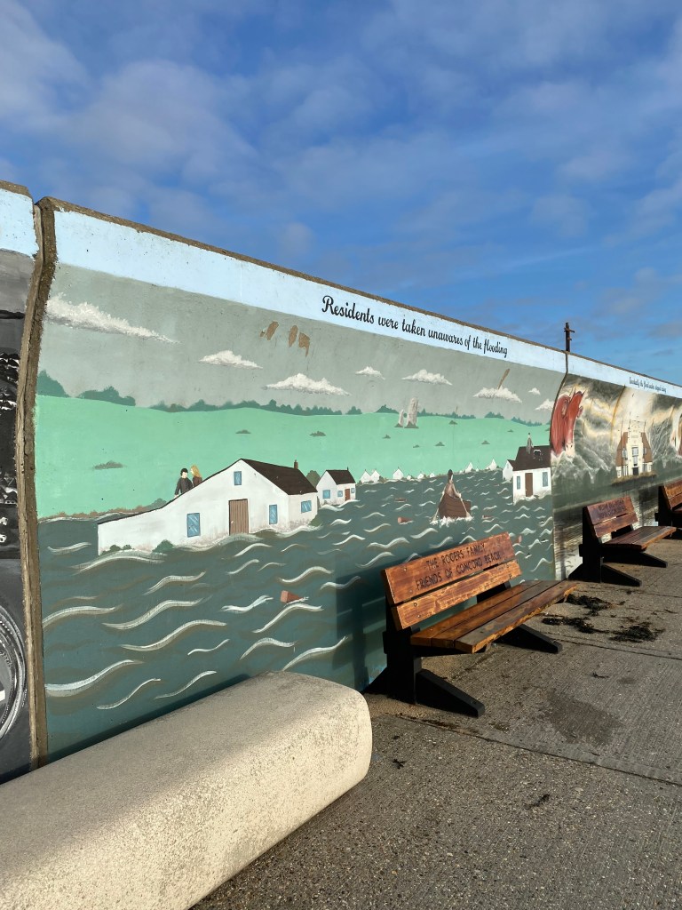


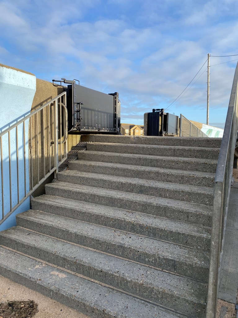

Images from the Sea Wall murals on Canvey Island, an example of the steel gates that now provide protection to the islanders, and houses lying on land that is as low as the level of the sea on the other side of the wall.
The trip gave me a powerful impetus to get the book started – and I have! I am writing this post now, partly to put a marker down that, hey, I’m doing this! Trying to make myself accountable. But also to draw attention to this terrible disaster that seems to have slipped from our national memory.
